Beyond the Limits

Experience Zimbabwe at Expo 2025 Osaka

Experience Now

Experience Zimbabwe

Victoria Falls

Virtual Tours

Experience Zimbabwe's majestic landscapes in stunning 9D virtual reality.
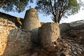
Cultural Dance

Cultural Heritage

Immerse yourself in Zimbabwe's rich cultural traditions and ceremonies.
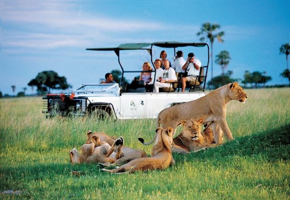
Wildlife

Wildlife Safari

Discover Zimbabwe's diverse wildlife through interactive experiences.

Venue Location

Japan

Yumeshima

Konohana Ward, Osaka, 554-0042

Get Directions

Investment Opportunities

Zimbabwe offers diverse investment sectors with high returns and strategic advantages in Southern Africa. Explore our featured sectors below and discover valuable opportunities across agriculture, ICT, manufacturing, mining, tourism, and infrastructure.

Loading investment opportunities...

Scroll for more opportunities
Project Image
Sector

Opportunity

Description

Project Scope

Financial Overview

Full Project Document

View the complete project document for comprehensive details about the investment opportunity.

Explore Zimbabwe's Provinces

Zimbabwe is divided into 10 provinces, each with unique attractions, resources, and investment opportunities. Explore the diverse landscapes, natural resources, and economic potential of each region.

Harare Province

Zimbabwe's Capital and Economic Hub

Introduction

Harare, Zimbabwe's capital and economic hub, is the nation's pulse, hosting key government institutions, financial centers, and multinational corporations. Renowned for its modern infrastructure, vibrant culture, and role as the country's commercial nucleus, it drives innovation in finance, ICT, and manufacturing.

Geographical Coverage

  • Total Land Area: 872 km² (smallest province)
  • Location: Northern Zimbabwe, on the Highveld plateau
  • Borders: Mashonaland East (east), Mashonaland West (northwest)
  • Key Features: Mukuvisi Woodlands, Lake Chivero, Epworth Balancing Rocks
  • Climate: Moderate temperatures (no extreme heat/snow), ideal for urban living

Administrative Structure

  • Local Authorities: Harare City Council, Chitungwiza Municipality, Epworth Local Board, Ruwa Town Council
  • Urban Centers: Harare City, Chitungwiza, Epworth, Ruwa
  • Infrastructure: Robert Gabriel Mugabe International Airport, major highways to all provinces
  • Education: University of Zimbabwe, Harare Institute of Technology

Population & Demographics

Population

~2.1 million (2023 estimate)

Density

Very high (3,000+ people/km²)

Urbanization

95% urbanized

Languages

Shona, Ndebele, English (fluency >90%)

Key Economic Sectors

Finance & Services
  • Reserve Bank of Zimbabwe, stock exchange, capital markets, multinational banks
  • Opportunities: Fintech, insurance, ICT startups
Manufacturing & Industry
  • Food processing, textiles, automotive assembly
  • Sunway City SEZ (Ruwa) – tech parks, medical hubs, manufacturing clusters
Tourism & Hospitality
  • National Gallery, Africa Unity Square, Zimbabwe Museum of Human Sciences
  • Mukuvisi Woodlands, Lion and Cheetah Park, National Botanical Gardens
Agriculture & Retail
  • Urban farming, horticulture, hydroponics in peri-urban areas
  • Mbare Musika (largest fresh produce market), Sam Levy's Village (luxury retail)

Bulawayo Province

Zimbabwe's Second City and Industrial Hub

Introduction

Zimbabwe's second-largest city and a historic industrial powerhouse, Bulawayo is a strategic logistics hub and gateway to southern Africa. Renowned for its railway heritage, multiculturalism, and proximity to iconic attractions like Matobo National Park, the city drives manufacturing, trade, and cultural tourism.

Geographical Coverage

  • Total Land Area: 1,706 km²
  • Location: Southwestern Zimbabwe, bordering Matabeleland North (north) and Matabeleland South (south)
  • Key Features: Semi-arid plains, Matobo Hills (UNESCO World Heritage Site)
  • Climate: Semi-arid, with moderate rainfall
  • Connectivity: Major rail/road junction linking Botswana, South Africa, and Zambia

Administrative Structure

  • Metropolitan Governance: Bulawayo City Council
  • Urban Centers: Bulawayo City (core), peri-urban zones (e.g., Tshabalala, Nkulumane)
  • Infrastructure: National Railways of Zimbabwe hub, Joshua Mqabuko Nkomo International Airport
  • Education: National University of Science and Technology (NUST), Zimbabwe School of Mines

Population & Demographics

Population

~653,000 (2023 estimate)

Density

High (urban focus)

Ethnic Groups

Ndebele (majority), Shona, Kalanga, Venda, Sotho

Languages

Ndebele, Shona, English

Key Economic Sectors

Manufacturing & Industry
  • Textiles (National Blankets), leather goods, food processing (Irvin & Johnson)
  • Industrial parks, machinery refurbishment
Tourism & Culture
  • Matobo National Park, Chipangali Wildlife Orphanage
  • Khami Ruins (UNESCO), Bulawayo Railway Museum, National Art Gallery
Logistics & Trade
  • Gateway for SADC trade via road/rail corridors
  • Logistics hub development, dry port feasibility studies
Agriculture & Energy
  • Dairy farms, beef ranching
  • Solar farms, industrial biogas initiatives

Manicaland Province

Eastern Highlands and Gateway to Mozambique

Introduction

Manicaland Province, nestled in Zimbabwe's eastern highlands, is a region of breathtaking landscapes, vibrant cultures, and dynamic economic potential. Renowned for its misty mountains, lush valleys, and strategic border access to Mozambique, the province serves as Zimbabwe's gateway to regional and international trade.

Geographical & Demographic Profile

  • Area: 36,459 km² (3.6 million hectares)
  • Borders: Mashonaland East (north), Masvingo (southwest), Mozambique (east)
  • Highlands: Eastern Highlands, Chimanimani Mountains
  • Rivers: Save River, Odzi River, Mtarazi Falls (Africa's 2nd-highest waterfall)
  • Climate: Ranges from alpine (Nyanga) to subtropical (Chipinge)
  • Population: ~1.8 million (60% rural, 40% urban)
  • Urban Centers: Mutare (capital), Rusape, Chipinge

Economic Powerhouses

Agriculture & Agro-Processing
  • Tea (60% national output), coffee, macadamia nuts, bananas, avocados
  • Timber (70% of Zimbabwe's production)
  • Green Fuel ethanol plant, organic banana exports, dairy (49% national milk output)
Mining & Minerals
  • Diamonds (Marange fields), gold, lithium, tantalite, phosphates
  • Diamond cutting/polishing hubs, lithium processing plants
Tourism & Hospitality
  • Nyanga National Park (hiking, trout fishing)
  • Chimanimani UNESCO Biosphere Reserve
  • Vumba Botanical Gardens & Coffee Tours
Manufacturing & Infrastructure
  • Timber processing (plywood, paper), fruit canning, textiles
  • Feruka Fuel Depot, Beira Corridor (300km to Mozambican port)

Mashonaland Central Province

Agricultural Heartland and Mining Hub

Introduction

A fertile agricultural and mining hub, Mashonaland Central is renowned for its tobacco, citrus, and gold production. With a favorable climate, robust educational institutions, and attractions like the Mavhuradonha Wilderness, the province drives Zimbabwe's agro-economy while offering untapped potential in mining and ecotourism.

Geographical Coverage

  • Total Land Area: 28,347 km²
  • Location: Northern Zimbabwe, bordering Mozambique (northeast)
  • Landscapes: Savannah grasslands, Mavhuradonha Wilderness, Umpfurudzi Game Reserve
  • Water Bodies: Mazowe Dam, Arcadia Dam, underutilized rivers
  • Climate: Tropical savannah, temperatures 20–30°C

Key Economic Sectors

Agriculture & Livestock
  • Tobacco (national leader), maize, cotton, citrus, soya beans
  • Cattle, goats, poultry (broilers, guinea fowls)
  • 42 irrigation schemes, honey production
Mining
  • Gold, nickel, platinum
  • Artisanal and large-scale mining operations
Tourism & Culture
  • Umpfurudzi Game Reserve, Tsambe Game Park
  • Sohwe Falls, Paradise Pools Resort, Chesvingo Ruins
  • Agro-tourism farms, traditional heritage sites
Education & Research
  • Bindura University (BUSE), vocational training centers
  • Agricultural research facilities

Mashonaland East Province

Agricultural Excellence and Mining Potential

Introduction

A hub of agricultural excellence and tourism, Mashonaland East is celebrated for its horticultural farms, lithium reserves, and scenic attractions like the Nyanga Mountains and Mutoko rock formations. It serves as a critical agro-processing and mining zone, bolstered by proximity to Harare and regional trade routes.

Geographical Coverage

  • Total Land Area: 32,230 km²
  • Location: Northeastern Zimbabwe, bordering Mozambique (east)
  • Landscapes: Eastern Highlands, Nyanga Mountains, Domborembudzi Mountain
  • Climate: Temperate (750–1,000 mm rainfall), ideal for farming
  • Districts: Chikomba, Goromonzi, Marondera, Murehwa, Mutoko, Seke, Uzumba-Maramba-Pfungwe (UMP), Wedza, Mudzi

Key Economic Sectors

Agriculture
  • Tobacco, maize, wheat, soya beans, horticulture (fruits, vegetables)
  • Dairy (milk processing), poultry, honey, and beef
  • Opportunities: Cold storage facilities, irrigation rehabilitation
Mining
  • Lithium: Largest deposits in Africa (6th globally), concentrated in Goromonzi
  • Granite: High-quality black granite in Mutoko/UMP
  • Granite extraction/polishing, lithium value-added processing
Tourism
  • Nyanga National Park, Manize/Makurumure waterfalls
  • Imire Game Park (Big Four)
  • Tsindi Ruins (Marondera), Mbende (Jerusalem) dance
Manufacturing & ICT
  • Agro-processing (dairy, cereals), furniture, granite products
  • Fiber-optic connectivity (Beira corridor), telecom infrastructure

Matabeleland North Province

Premier Tourism and Mining Hub

Introduction

A premier tourism and mining hub, Matabeleland North is home to iconic landmarks like Victoria Falls and Hwange National Park. The province drives Zimbabwe’s energy sector through coal and hydropower, while its vast wildlife and cultural heritage anchor sustainable tourism.

Geographical Coverage

  • Total Land Area: 75,025 km² (largest province)
  • Location: Northwestern Zimbabwe, bordering Zambia (north) and Botswana (west)
  • Key Features: Zambezi River, Kalahari Desert sands, Hwange grasslands
  • Climate: Semi-arid to temperate, with seasonal rainfall

Administrative Structure

  • Districts: 7 (Binga, Bubi, Hwange, Lupane, Nkayi, Tsholotsho, Umguza)
  • Urban Centers: Victoria Falls, Hwange, Lupane (capital), Binga

Key Economic Sectors

Tourism & Hospitality
  • Attractions: Victoria Falls, Hwange National Park, cultural sites
Mining & Energy
  • Key Resources: Coal, gold, diamonds, lithium, tin
Agriculture & Forestry
  • Livestock: Cattle ranching, goat farming
  • Crops: Drought-resistant small grains

Matabeleland South Province

Strategic Trade Gateway and Cultural Heartland

Introduction

A strategic trade gateway and cultural heartland, Matabeleland South is renowned for its UNESCO-listed Matopos National Park, rich mineral deposits, and vibrant cultural diversity.

Geographical Coverage

  • Total Land Area: 54,172 km²
  • Location: Southern Zimbabwe, bordering Botswana (west) and South Africa (south)

Administrative Structure

  • Districts: 7 (Gwanda, Beitbridge, Bulilima, Mangwe, Matobo, Insiza, Umzingwane)
  • Urban Centers: Gwanda (capital), Beitbridge, Plumtree

Key Economic Sectors

Mining & Natural Resources
  • Key Minerals: Gold, diamonds, platinum, lithium, copper
Agriculture & Livestock
  • Livestock: Indigenous cattle breeds, goat farming
Tourism & Culture
  • Natural: Matopos NP (white rhinos, leopards), Lumene Falls

Midlands Province

Geographic and Economic Heartland

Introduction

Midlands Province, Zimbabwe’s geographic and economic heartland, pulses with mineral wealth, agricultural vitality, and industrial prowess. Strategically positioned at the crossroads of the nation, it connects six provinces and thrives as a hub for mining, agriculture, and heavy industry.

Geographical Coverage

  • Area: 49,166 km²
  • Borders: Mashonaland West, Mashonaland East, Masvingo, Matabeleland North, Matabeleland South

Administrative Structure

  • Urban Centers: Gweru (capital), Kwekwe, Shurugwi, Zvishavane, Mvuma, Gokwe

Key Economic Sectors

Mining & Minerals
  • Key Resources: Gold, platinum, lithium, chrome
Agriculture & Livestock
  • Key Products: Cotton, maize, tobacco
Manufacturing & Industry
  • Hubs: Steel, cement, textiles

Mashonaland West Province

Strategic Economic and Tourism Hub

Introduction

A strategic economic and tourism hub, Mashonaland West is renowned for its tobacco production, mineral wealth (gold, platinum), and iconic attractions like Lake Kariba and the Chinhoyi Caves. The province is a key contributor to Zimbabwe’s energy sector through the Kariba Dam hydroelectric plant.

Geographical Coverage

  • Total Land Area: 57,441 km² (second-largest province)
  • Location: Northern Zimbabwe, sharing an international border with Zambia
  • Key Features: Lake Kariba, Zambezi River, Mazvikadei Dam
  • Climate: Temperate, with fertile soils ideal for diverse crops

Administrative Structure

  • Districts: 7 (Kariba, Hurungwe, Makonde, Mhondoro-Ngezi, Sanyati, Zvimba, Chegutu)
  • Urban Centers: Chinhoyi (capital), Kadoma, Chegutu, Norton, Karoi, Kariba

Key Economic Sectors

Agriculture
  • Main Products: Tobacco, maize, cotton, wheat, soya beans
  • Opportunities: Irrigation infrastructure, agro-processing
Mining
  • Key Minerals: Gold, platinum, chrome, copper, limestone
Tourism
  • Attractions: Lake Kariba (houseboat cruises, fishing), Mana Pools, Chinhoyi Caves
Energy
  • Power Generation: Kariba Hydroelectric Plant, solar farms

Masvingo Province

Historical and Ecological Treasure

Introduction

A historical and ecological treasure, Masvingo is home to the Great Zimbabwe Monuments (a UNESCO World Heritage Site) and Zimbabwe’s largest sugar estates. Renowned for its lithium reserves, vast cattle herds, and transfrontier wildlife parks, the province drives agro-industry, mining, and cultural tourism.

Geographical Coverage

  • Total Land Area: 56,566 km²
  • Location: Southeastern Zimbabwe, bordering Mozambique (east)
  • Key Features: Lowveld plains, Chilojo Cliffs, Lake Mutirikwi
  • Climate: Semi-arid, suited for drought-resistant farming

Administrative Structure

  • Districts: 7 (Bikita, Chiredzi, Chivi, Gutu, Masvingo, Mwenezi, Zaka)
  • Urban Centers: Masvingo City (capital), Chiredzi, Rutenga

Key Economic Sectors

Agriculture & Livestock
  • Crops: Sugarcane, cotton, drought-resistant grains
  • Livestock: 1+ million cattle, poultry, goat farming
Mining & Energy
  • Key Resources: Lithium, diamonds, tantalite
  • Energy: Hydropower (Tokwe-Mukosi), solar farms
Tourism & Culture
  • Attractions: Great Zimbabwe Monuments, Gonarezhou NP

Travel to Zimbabwe

Plan your journey to Zimbabwe and discover the warm hospitality, breathtaking landscapes, and rich cultural heritage of this remarkable destination.

Zimbabwe Tourism at Expo 2025 Osaka

Due Date: 02/05/2025
Zimbabwe Tourism at Expo 2025 Osaka

Join the Ministry of Tourism & Hospitality Industry and the Zimbabwe Tourism Authority to showcase Zimbabwe's Tourism Excellence at Expo 2025 in Osaka, Kansai, Japan!

Discover opportunities to promote Zimbabwe's natural wonders, cultural heritage, and tourism attractions on a global stage.

Tourism Videos

Tourism Video QR Code

Scan to watch stunning videos showcasing Zimbabwe's natural wonders and cultural treasures.

Open Link

MICE Tourism

MICE Tourism QR Code

Discover why Zimbabwe is the perfect destination for Meetings, Incentives, Conferences, and Events.

Open Link

Tourism Publications

Tourism Publications QR Code

Access the latest newsletters and publications from Zimbabwe Tourism Authority.

Open Link

Tourism Brochure

Tourism Brochure QR Code

Browse through our comprehensive tourism brochure showcasing Zimbabwe's finest destinations.

Open Link

Live Streams & Events

Upcoming Live Stream

Join us for our upcoming live stream event and engage with our community.

Watch Now

Upcoming Events

  • Tourism Booth 06 - 20 June 2025
  • Business Forum 15 July 2025
  • National Day 16 July 2025
  • Roadshow -- Nagoya 18 July 2025
  • Roadshow -- Tokyo 20 July 2025

Our Future

2025 Vision

Sustainable development and economic growth

Contact Us

Get In Touch With Us For More Information:

Email: zimoasakaa@zimtrade.co.zw

Tel: +263 242 369 330

Whatsapp: +263 773 358 129

]